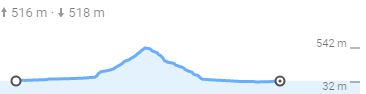
This loop is called “The loop of Il Castagno” from the name of the place that splits it into two halves. It is one of the most popular itineraries among local cyclists. It goes along the external border of the municipality of Peccioli, passing through some neighboring municipalities and hitting the settlements of La Rosa, La Sterza, Molino d’Era, Il Castagno, San Vivaldo, Castelfalfi and Forcoli. The route mainly develops on roads with little traffic, following the contours of gently sloping hills and featuring wonderful views of the Tuscan countryside. The maximum height difference of 385m is achieved in the stretch between Molino d’Era and Il Castagno, in a distance of 11Km which makes it easy to bike.
Distances and altitude differences
Total distance: 66km
Altitude difference: 444m
Roads: paved
| Step | Difference in Alt. (mt.) | Altitude (mt. asl) | Partial dist. (Km) | Total distance (Km) |
|---|---|---|---|---|
| Peccioli – Portavaldera – Partenza | 0 | 46 | 0 | 0 |
| La Rosa | 12 | 58 | 2,8 | 2,8 |
| La Sterza | 22 | 80 | 5,3 | 8,1 |
| SR 439dir | -4 | 76 | 4,8 | 12,9 |
| Molino d’Era | 29 | 105 | 6,9 | 19,8 |
| Il Castagno | 385 | 490 | 11,5 | 31,3 |
| San Vivaldo | -80 | 410 | 5,3 | 36,6 |
| Castelfalfi | -150 | 260 | 4,7 | 41,3 |
| Forcoli | -210 | 50 | 18,2 | 59,5 |
| Peccioli – Portavaldera – Arrivo | -4 | 46 | 6,9 | 66,4 |
MAPS